Manitoba Upgrades Fisher River Flood Outlook to High Risk — Interlake Homeowners Warned of 2014-Level Peguis Flood Potential
Province's April 7 Update Puts Fisher River on a Trajectory That Could Match 2014 — Or Approach 2022
By
Published: April 10, 2026
Credit: Shutterstock
Key Takeaways
•Manitoba's Hydrologic Forecast Centre upgraded the Fisher River basin to high flood risk on April 7, 2026, citing snowpack nearly double the long-term average.
•Under median weather, Fisher River peak flows are expected to match the 2014 Peguis flood; under unfavourable conditions, levels could approach 2022 — roughly two feet higher.
•Interlake homeowners have a short window before peak runoff to check sump pumps, service backwater valves, elevate basement valuables, and confirm their policy covers overland flooding.
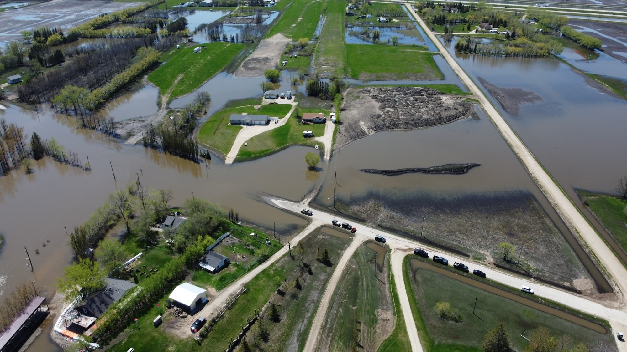
On April 7, 2026, Manitoba's Hydrologic Forecast Centre did something it rarely does mid-season: it updated the provincial spring flood outlook with a single basin-specific escalation. The Fisher River, in the Interlake region, is now at high flood risk — and the bulletin used a comparison that removes any ambiguity about what that means. Under median weather, peak flows are expected to match the 2014 Peguis flood, the event that displaced more than a hundred people and, years later, still has hundreds of Peguis First Nation members living away from home.
That is the anchor. Everything else in this update — the snowpack figures, the delayed melt, the scenario language — is the province explaining, in hydrologic terms, why a 2014-scale event has moved from "possible" to "expected under normal weather." For homeowners along the Fisher and Icelandic rivers, and for small-town residents across the Interlake, the usable window to prepare is now measured in weeks, not months.
This is the first Manitoba-specific escalation in the 2026 flood season, following earlier Yukon spring flood warnings tied to above-average snowpack. It is also the first update this year that pairs a risk upgrade with a concrete, community-level historical benchmark. That combination is what turns a bulletin into a call to act.
Stay on top of Canadian homeowner news
What the April 7 Update Actually Says
The Hydrologic Forecast Centre (HFC), housed within Manitoba Transportation and Infrastructure, is the province's standing authority for river and lake forecasting. It issues spring flood outlooks through late winter and early spring, and updates them when hydrologic or meteorological conditions shift enough to change the risk picture. The April 7 bulletin is one of those updates. Outside the Interlake, the province's overall outlook is largely unchanged from March — moderate risk continues along portions of the Red, Assiniboine, Souris, Saskatchewan and Carrot rivers, and most tributaries and eastern basins remain at low risk. The change is concentrated, almost entirely, in one basin.
Inside the Fisher River basin, the language shifted. Spring flood risk remains high. Flow forecasts suggest elevated potential throughout the basin. Under median forecast conditions, peak flows are expected to reach levels similar to those observed during the 2014 spring flood. Under unfavourable weather, flows could approach levels seen during the 2022 flood — which were roughly two feet higher than 2014. The nearby Icelandic River continues to face a moderate risk of flooding, with ice-jam flooding flagged as the primary concern even under a generally moderate outlook.
The province also confirmed that Portage Diversion operations are expected to begin this week to manage ice-related flows on the Lower Assiniboine, while the Red River Floodway is not expected to operate under normal or favourable weather. That operational picture — infrastructure running within its design envelope, no province-wide structural emergency — is the frame the province is asking Manitobans to hold in mind. This is not 2011. It is a sharp, localized escalation in one basin with an unusually complete historical analog.
Important
The April 7 bulletin is not a general Manitoba flood warning. It is a targeted upgrade for the Fisher River basin, with the rest of the province holding at its March risk levels. If you live in the Interlake — particularly along the Fisher or Icelandic rivers — the bulletin is speaking directly to you. If you live elsewhere in southern Manitoba, the moderate-risk posture that has been in place since March remains the operating picture.
Why the Fisher River Risk Jumped
Three things changed the outlook, and they stack in a way that is unusually clean from a forecasting standpoint. The first is snowpack. Recent provincial snow surveys indicate that snow-water equivalent across the Fisher River basin is among the highest observed in recent years, with forecast snowfall potentially pushing it to approximately 110 millimetres — nearly double the long-term average and equal to or greater than levels seen in several past flood years. The water is already sitting on the landscape, frozen. It has to go somewhere.
The second is timing. Temperatures are expected to remain near zero through mid-April, delaying the onset of snowmelt. A delayed melt sounds, intuitively, like good news — more time, more gradual runoff. It is often the opposite. When melt is compressed into a shorter window by a late warm-up, peak flows rise sharply even if total snow volume is unchanged. Add spring rainfall on top of a concentrated melt, and the runoff event becomes exactly the kind of rapid, high-peak scenario the HFC flags as the risk driver.
The third is scenario probability. In its March outlook, the HFC had already flagged the Fisher River basin as having moderate-to-major flood risk under normal weather, with median peak flows at Dallas forecast near 2,900 cfs and upper-decile flows near 4,200 cfs — comparable to 2014 levels under unfavourable conditions. What changed between March and April is not the existence of those scenarios. What changed is how likely the upper end has become. The April bulletin effectively says: the conditions that would previously have been a tail scenario are now the central expectation.
How to Read "Median" and "Unfavourable"
Manitoba's spring outlooks run three weather scenarios — favourable, normal, and unfavourable — which correspond to lower-decile, median, and upper-decile probability outcomes. Median is the fifty-percent case: roughly, what the province expects if weather plays out as its central forecast suggests. Unfavourable is the upper-tail case, a lower-probability but higher-impact scenario that the province uses as the basis for planning and preparedness work even when it is not the most likely outcome.
This matters because the April 7 bulletin uses both labels. Under median conditions — the central case — Fisher River peaks are expected to match 2014. That is not a warning about what could happen. It is a forecast of what is currently expected. Under unfavourable conditions — the planning case — peaks could approach 2022, which ran about two feet higher. The province's own protocol is to plan around the unfavourable scenario. For homeowners, that is the right benchmark to hold in mind while deciding what to do this week.
Scenario
What It Means
Fisher River Outcome
Community Analog
Median (normal weather)
~50% probability case; central forecast
Peak flows match 2014
2014 Peguis spring flood
Unfavourable (upper-decile)
Upper-tail case; used for provincial planning
Peak flows approach 2022
2022 Peguis flood (~2 feet higher than 2014)
Favourable (lower-decile)
Lower-tail case; best-plausible weather
Elevated risk persists given existing snowpack
Below both benchmark years
What the 2014 and 2022 Benchmarks Signal
The value of the Peguis comparison is that it is not abstract. The 2014 Fisher River flood forced more than a hundred people from their homes in Peguis First Nation, and the 2022 flood was larger and more damaging still. Canadian Press reporting later documented that more than 500 Peguis members displaced by 2022 had still not returned by 2024, alongside roughly 235 people who had been displaced by earlier 2014 and 2017 events. The point isn't that the 2026 event will reproduce those outcomes for any specific community. It is that a Fisher River basin flood of that scale is not a short-lived emergency. It is a multi-year housing and health event.
For homeowners further downstream of Peguis — in small Interlake towns, along the Icelandic River corridor, in lower-lying rural properties — the practical read is this: the 2014 and 2022 benchmarks describe the energy and volume of water now expected to move through the basin. A home doesn't need to be on a reserve, or on a named flood plain, to feel the effects of a runoff event of that magnitude. Saturated soils, rapid overland flow, ice-jam backups, and sewer-system strain all travel further than the river itself.
Warning
Ice-jam flooding is a distinct hazard from overland or river flooding. It can raise water levels suddenly and locally, even when the overall basin outlook looks moderate. The Icelandic River is flagged specifically for ice-jam risk in the April update. If your property is near either the Fisher or Icelandic, monitor conditions through the melt, not just the HFC's headline risk categories.
The Rest of Manitoba: Moderate, Not Elevated
It is worth holding the Interlake escalation in its proper proportion. The same April 7 bulletin explicitly confirms that the overall provincial picture is unchanged from March. Moderate flood risk continues along portions of the Red, Assiniboine, Souris, Saskatchewan and Carrot rivers. Low risk is expected for Red and Assiniboine tributaries and for much of eastern Manitoba, including the Winnipeg River basin. The Shellmouth Reservoir has been pre-lowered in preparation for runoff, the Portage Diversion is being set up to run inside its ice-management envelope, and the Red River Floodway is not expected to be activated under normal weather.
That is the difference between a general provincial flood year and a basin-specific escalation. Homeowners outside the Interlake should not let the Fisher River headline reshape their expectations for their own neighbourhood — but homeowners on any moderate-risk river should still treat the spring melt as the annual moment to verify sump pumps, clear downspout extensions, and confirm insurance coverage. Moderate risk is not a clean bill of health. It is the baseline at which preparation makes a measurable difference in claim outcomes. Our earlier coverage of Ontario and Manitoba's March spring flood warnings established the pre-season baseline; the April 7 Interlake update is the first mid-season escalation of that picture.
What Interlake Homeowners Should Do Before Peak Runoff
The delayed melt is a planning gift, not a reason to relax. For the next two to three weeks, the Fisher River basin is holding its snowpack while the province is telling homeowners, as plainly as a provincial bulletin gets, that a 2014-scale flood is the central expectation. The useful question is not whether to prepare. It is what to do with the short window the weather has opened.
The provincial Emergency Information for Seniors guide — written for a broader audience than its title suggests — lays out the frontline defences for basement flooding in plain terms: improve drainage by sloping ground away from the foundation and extending downspouts, prepare plugs for basement drains, install or service valves on sewage pipes to resist sewer backups, and run sump pumps to remove water that does enter.
The Intact Centre on Climate Adaptation's basement flood protection checklist adds the specifics: test sump pumps and backup power, clean out backwater valves, correct lot grading so water moves at least two metres from the foundation, extend sump discharge pipes, maintain window well covers, and move valuables and hazardous materials into watertight containers or above floor level.
Translated into a Fisher River basin action sequence for this specific window:
This week: Test the sump pump under load (pour a bucket of water into the pit), confirm the backup power source works, and verify the discharge pipe is not frozen or buried in snow. Clear any remaining ice or snow from the first two metres of ground around the foundation so meltwater has somewhere to go other than the basement.
Before mid-April: Have a plumber service the backwater valve if one is installed; if not, this is the time to call. Install temporary drain plugs in basement floor drains. Elevate anything on a basement floor that would be ruined by a few inches of water — mechanical gear, paper records, electronics, mattresses, anything with a power cord.
During the melt: Monitor the sump pump audibly. Keep an eye on ground settling and visible water pooling near the foundation. Photograph pre-existing basement conditions so any subsequent damage is well-documented for an insurance claim. Do not wait for visible water to move belongings; the first inch often arrives without warning through a floor drain or cold joint.
After the melt: If water entered the basement, the first 24 hours drive the total claim cost. Moving on mould-prone materials early is the difference between a remediation and a rebuild.
Backwater Valve Grants Exist — and They Matter More Than Most Homeowners Realize
The backwater valve is the single piece of plumbing that most directly reduces risk of sewer backup during a concentrated runoff event, and the province has been quietly subsidizing them in Manitoba's larger cities for years. Winnipeg's Basement Flooding Protection Subsidy Program offers homeowners roughly $1,000 for an in-line backwater valve, $2,000 for a sump pit drainage system, or $3,000 for installing both, conditional on permitted and inspected work. Brandon runs a parallel 2026 Flood Protection Subsidy Program covering up to 75 percent of eligible costs, to a maximum of $2,500 for a sump pump and pit and $1,500 for a backwater valve, with installations completed and inspected by December 15, 2026.
Interlake communities are not covered by either of those municipal programs, but the existence of the programs matters anyway. It establishes that provincial and municipal governments treat backwater valves and sump pits as the two most cost-effective public investments for basement flood mitigation. If you live in a smaller Interlake community, the question worth asking your reeve or council this week is whether any cost-share program exists locally — and if not, whether the municipality can flag eligibility to any provincial disaster mitigation funding that may become available once the flood response ramps up.
Tip
If you are going to spend on one upgrade this month, service or install the backwater valve. It is the piece of plumbing that specifically protects against the scenario the HFC is forecasting: rapid runoff overloading municipal sewer capacity and pushing sewage back through floor drains. A sump pump addresses water that has already entered the basement. A backwater valve prevents the highest-damage failure mode from starting in the first place.
The Overland Flood Insurance Gap
The last, and most frequently overlooked, piece of basement flood preparation is the insurance policy itself. Overland flood — the category that covers water entering a home from surface sources like melting snow, rising rivers, or rainfall that exceeds drainage capacity — is not automatically included in a standard Canadian home insurance policy. It is an add-on, introduced by Canadian insurers after the 2013 Alberta and Ontario floods, and it is not universally purchased. The Insurance Bureau of Canada has estimated that only about 10 to 15 percent of Canadian homeowners carry it, while the average insured cost of cleaning up a flooded urban basement sits around $40,000. The gap between those two numbers is the blind spot this bulletin is, indirectly, asking Interlake homeowners to close.
There are three flood-related coverage categories a homeowner should be able to name before peak melt arrives. Sewer backup coverage is the most common and is often included or offered as an inexpensive add-on — it covers water entering through the sewer system, typically via a floor drain. Overland flood coverage is the newer add-on and is what responds to surface water from snowmelt, ice-jam backups, and rising rivers. Ground water or seepage through the foundation is generally excluded from both, and is the exclusion most homeowners discover only after a claim is denied. The operational question for this week is simpler than the category taxonomy suggests: call the broker, ask what is covered, ask what the deductible is, and ask whether overland flood is on the policy. If the answer is "no" or "I'll have to check," assume it is not, and ask what it would cost to add.
The City of Winnipeg's own guidance on property flood risk distinguishes cleanly between basement, overland, and river flooding as three different hazards — and notes that creeping water from retention ponds, creeks, ditches, and excess snowmelt can cause overland flooding on properties well away from main rivers. That is important framing for Interlake homeowners who might assume overland flood risk only applies to riverfront properties. Rapid melt on saturated ground, combined with frozen or obstructed drainage, produces overland flooding on lots that look safely distant from any named river on a map.
Adding overland flood coverage mid-season is sometimes possible, but insurers may impose waiting periods or decline new binds once a specific flood event is imminent. The time to add overland coverage was last month. The second-best time is today. The worst time is after peak runoff begins.
What to Watch Over the Next Two Weeks
The HFC will continue to update the forecast as weather and runoff conditions evolve, and its bulletins are the authoritative source for Interlake homeowners over the next two to three weeks. For property-level context, NRCan's updated Canada flood map inventory is the right place to check whether your specific parcel sits in a mapped flood-risk area before — not during — the melt. The key variables to watch are the timing of the warm-up (a gradual melt lowers peak flows; a late, fast warm-up raises them), any spring rainfall during the melt window (which compounds runoff), and ice movement on the Fisher and Icelandic rivers (which determines whether ice-jam flooding becomes a localized factor on top of the basin-wide runoff picture). The Manitoba Emergency Management Organization is working with local authorities, First Nations, and emergency management partners on response planning, and community-level updates will come through those channels as conditions change.
For homeowners, the frame is straightforward. The province has told you, in the most specific language it uses, that a 2014-scale Fisher River flood is now the central expectation, and a 2022-scale event is the planning case. The infrastructure that matters is in your basement, at your foundation, and on your insurance policy. The next two weeks are the window in which each of those is still cheaper to fix than to claim.
Ryan is the founder of Homeowner.ca and a proud Canadian homeowner based in Guelph, Ontario. Over his 25-year career in digital publishing, he has focused on transforming complex information into clear, practical guidance that helps people make confident, well-informed decisions.
Manitoba Transportation and Infrastructure, Hydrologic Forecast Centre. (2026, March). March 2026 Spring Flood Outlook Report. Retrieved from https://www.gov.mb.ca/floodinfo/
City of Brandon. 2026 Flood Protection Subsidy Program. Retrieved from https://www.brandon.ca/
City of Brandon. Permits and Applications — Building and Plumbing. Retrieved from https://brandon.ca/
Q Country FM. (2026, April 8). Province warns of elevated flood risk in Interlake; Westman holds at moderate levels. Retrieved from https://qcountryfm.ca/
Winnipeg Free Press. (2024, May 1). Manitoba First Nation declares state of emergency over flooding-related health crisis. Retrieved from https://www.winnipegfreepress.com/
Coast Reporter. Manitoba First Nation declares state of emergency over flooding-related health crisis. Retrieved from https://www.coastreporter.net/